Satellite Imagery Reveals UK Landscape's Struggle with Heatwaves and Drought
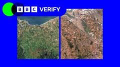
Satellite images analyzed by BBC Verify reveal significant "vegetation stress" across the UK landscape, a direct consequence of recent heatwaves and drought conditions. This widespread stress poses potential threats to both wildlife and agricultural productivity. The analysis highlights areas where plant life is visibly suffering, indicating a decline in health and resilience due to insufficient water and extreme temperatures. Farmers may face challenges in crop yields and livestock management as the dry conditions persist. Wildlife habitats could also be impacted, affecting biodiversity and ecosystem stability. The findings underscore the vulnerability of the UK's natural environment to climate change-induced weather extremes. Further monitoring will be crucial to understand the long-term effects on the landscape and the sectors reliant upon it. The data provides a stark visual representation of the environmental challenges currently facing the nation.
The satellite data provides an objective measure of environmental stress, decoupling the phenomenon from emotional framing. This visual evidence of vegetation stress, linked to heatwaves and drought, highlights the tangible impacts of climate variability on natural and agricultural systems. Future assessments should consider the interplay between land management practices, water resource availability, and the increasing frequency of extreme weather events. Understanding these dynamics is crucial for developing adaptive strategies that enhance ecosystem resilience and ensure food security in the face of evolving climatic conditions over the next decade.
AI-generated to prompt reflection — not editorial opinion, not advice, not a statement of fact. How this works.