Sergipe Government Submits Boundary Study for Aracaju and São Cristóvão to IBGE
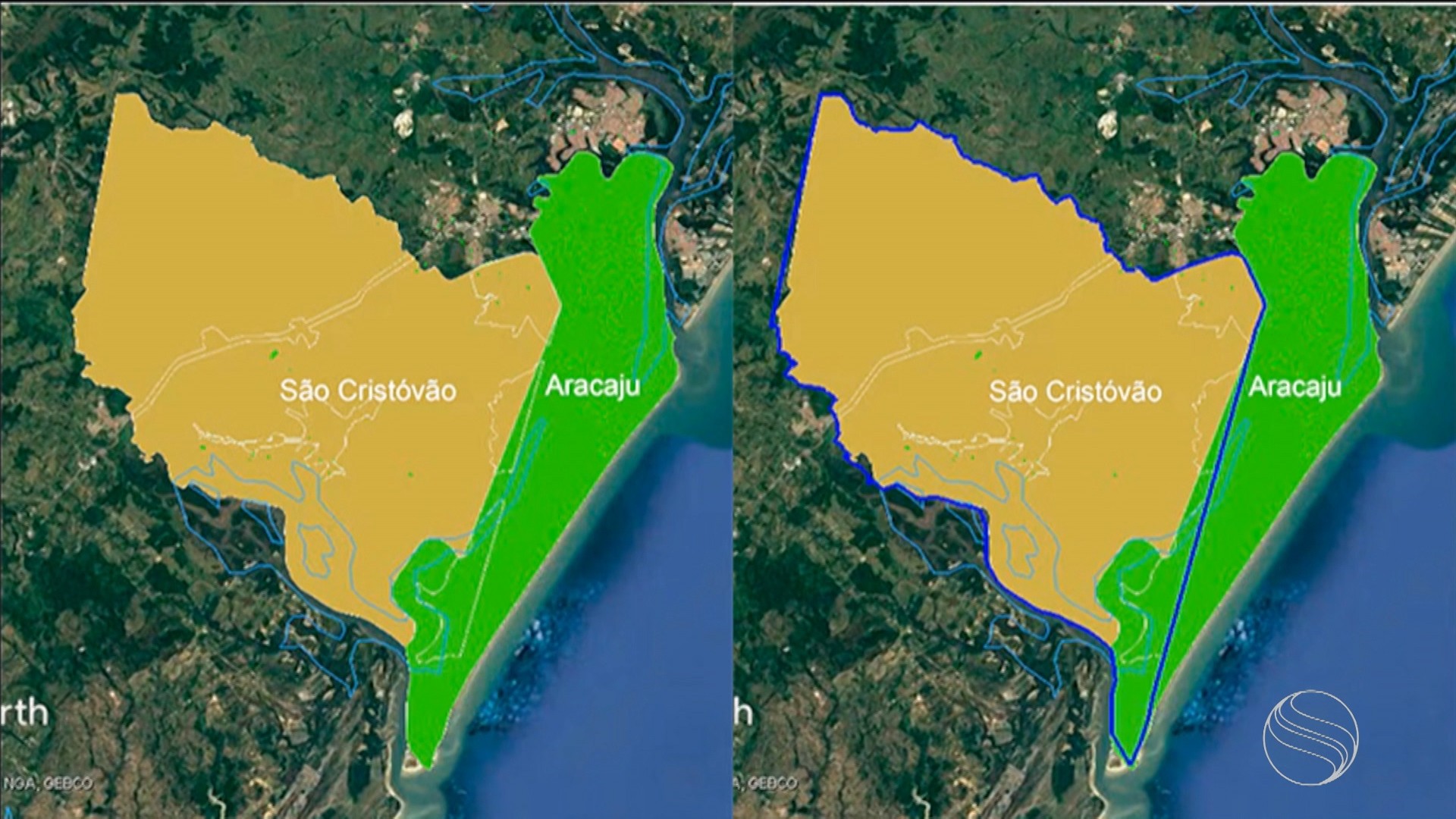
The Sergipe Special Secretariat of Planning, Budget, and Innovation (Seplan) has submitted a study detailing minor adjustments to the territorial boundaries between Aracaju and São Cristóvão to the Brazilian Institute of Geography and Statistics (IBGE). This study, which includes the relocation of residences and natural features, is crucial for the IBGE to officially update the municipalities' cartography. The adjustments were developed collaboratively with representatives from both cities following an agreement reached in Federal Court. According to State Planning Secretary Júlio Filgueira, the process involved on-site assessments and cartographic studies to determine how the borders should be redrawn, allowing both municipalities to identify which residences, businesses, and public facilities will fall under each city's jurisdiction. The revised map indicates that approximately 25% of the Mosqueiro neighborhood, including the Orlinha Pôr do Sol area, will now be part of São Cristóvão. Similarly, most of the Matapuã neighborhood will also be incorporated into São Cristóvão, while the Areia Branca neighborhood will be roughly divided between the two cities. The Santa Maria neighborhood will see only a small, sparsely populated area transferred to São Cristóvão. For São Cristóvão, this boundary redefinition is expected to increase its share of federal transfers like the Fundo de Participação dos Municípios (FPM), although it will also assume responsibility for providing public services in the newly incorporated areas. Diego Araújo, sub-prosecutor of São Cristóvão, stated that the municipality is prepared to manage the new territory and that a timeline for administrative transfer is being established. The Aracaju Municipal General Prosecutor's Office declined to comment at this time. A recent Senate-approved bill mandates plebiscites before municipal boundary changes, but Secretary Filgueira noted that legal deadlines make holding a plebiscite for the 2026 elections unfeasible, requiring a minimum 60-day notice. The Sergipe Legislative Assembly (Alese) confirmed its oversight of the judicial decision and the technical agreement signed on July 17th, which has been sent to the IBGE and Federal Court. Alese will initiate the municipal feasibility study, a federal requirement, after the technical and judicial processes are concluded. The new boundary was ultimately defined in 2024 after the Supreme Federal Court (STF) upheld a 2012 Federal Court ruling that found Aracaju's unilateral boundary changes in 1989 unconstitutional.
This territorial boundary adjustment between Aracaju and São Cristóvão, formalized through a judicial process and now awaiting IBGE's cartographic update, reflects a complex interplay of municipal governance, resource allocation, and historical legal disputes. The redefinition, driven by a Supreme Court ruling that corrected past unconstitutional unilateral actions, aims to establish a more equitable distribution of territory and associated fiscal benefits, such as increased FPM transfers for São Cristóvão. However, this also entails the assumption of new public service responsibilities, presenting a fiscal and administrative challenge for the receiving municipality. The current legal framework, emphasizing plebiscites for boundary changes, introduces procedural complexities and potential delays, highlighting a systemic tension between democratic local consent and the efficiency of administrative corrections. Looking ahead, the integration of these areas will require careful inter-municipal coordination to ensure seamless service delivery and avoid creating disparities for residents affected by the new boundaries, underscoring the need for robust intergovernmental fiscal and administrative frameworks in Brazil's municipal landscape.
AI-generated to prompt reflection — not editorial opinion, not advice, not a statement of fact. How this works.