US State Department Embarrassed by Erroneous Africa Map
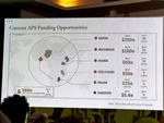
The U.S. Department of State has faced criticism following the publication of an incorrect map of Africa. The map erroneously depicted Nigeria as a landlocked country situated within the Sahara Desert. Additionally, Mozambique was misplaced and shown in the Horn of Africa region. This cartographical error has led to embarrassment for the department.
The inadvertent misrepresentation of African geography by a prominent government body like the U.S. State Department highlights potential systemic issues in data verification and quality control processes. Such errors, while seemingly minor, can undermine public trust and reflect broader challenges in accurately portraying global regions. In an era increasingly reliant on precise data for policy, diplomacy, and public understanding, the incident underscores the critical need for robust internal review mechanisms to ensure the accuracy of publicly disseminated information. This event serves as a case study for improving geopolitical data management and the consequences of even small inaccuracies in official communications.
AI-generated to prompt reflection — not editorial opinion, not advice, not a statement of fact. How this works.